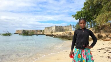
Travel Blog

ROAD TO HARAR

The road from Chiro to Harar offers a mixed landscape with some beautiful scenery, but it is also marked by rough, chaotic traffic in the smaller towns along the way. The tarmac was good, with a few short, damaged sections, so driving through the Ethiopian Highlands was not so bad, with...

ROAD TO CHIRO

We started early morning in Addis Ababa, took a highway (70 ETB), and continued on a pretty good tarmac road up to Awash National Park, where we made a half-day excursion with a local ranger (600 ETB), then continued through mountainous scenery to Chiro. It is a town and former...

AWASH NP

Awash National Park is located in central Ethiopia, situated in the Great Rift Valley between the Oromia and Afar regions, approximately 225 km from Addis Ababa. Geographically, it is characterised by a semi-arid climate, grasslands, savannas, and shrubs, with altitudes ranging from 712...

CATTLE MARKET

We drove to the Hargeisa livestock market, a major livestock trading hub located on the southeastern outskirts of the city. We found a local “strong and tough” woman, who was ready to guide us through and arrange some photos (10 USD) for us; otherwise, the locals would eat us...

GACAN LIBAAX

Today we did a rough off-road drive in a hired Toyota (200 USD) around the Gacan Libaax mountain range at 1,720 meters above sea level. The name “Gacan Libaax” translates to “The lion’s paw”. It is known for its unique juniper forests and ancient rock art...

SHEIKH MOUNTAINS

Later, we slowly drove on perfect tarmac through the Sheikh Mountains, a part of the Golis Mountains that form the rugged northern edge of the Somali plateau and run parallel to the Gulf of Aden. The mountains have a significant range in elevation, with the highest peak in Somaliland...

BERBERA (بربرة)

In the morning, we finally went to explore Berbera. First, we drove to the historic port, which is now part of the new port complex. It’s not possible to get there, but we got a permit via friends to drive through the port. Unfortunately, we were not allowed to get out of our car...

ROAD TO BERBERA

We drove on perfect tarmac for about 160 kilometres from Hargeisa to Berbera. We travelled from the high-altitude (1,334 m), inland city of Hargeisa, descending to the coastal town of Berbera. The wide road runs through the Galgodon Highlands and then down to the coast of the Gulf of...

LAAS GEEL

On our way to Berbera, we made a stop and a short off-road drive to Laas Geel, a cave complex famous for ancient rock paintings dating back to the Neolithic period, roughly 9,000 to 3,000 BCE (🎟️35 USD, paid in office in Hargeisa). Other sources suggest a date of around 6,000 years ago...

CAMEL FARM

Today, late afternoon, we drove a few kilometres behind the capital to see the milking of camels. Camels have historically been central to Somali culture, symbolising status and pride. Camel farms in Somaliland, particularly in Hargeisa, are a significant part of the nation’s...